Way back in 2003 for the Nationals on Buzzards Bay, I wrote an article that described the Buzzards Bay Sou’wester as it was pretty easy to describe the “standard conditions” there. Sadly – or fortunately, depending on your perspective – there is no simple analogy for sailing in Annapolis on the Chesapeake Bay beyond the old adage:
When the wind is from the south, go right. When the wind is from the north, go left. When the wind is from the east, go to Marmadukes*!
-Stuart Walker
* A history side note for you new to the Annapolis area, Marmadukes was the old “sailor’s bar” of the 70s-80s, the building that is now Ruth’s Cris Steakhouse. Boatyard Bar and Grill is a gentrified current day Marmadukes.
The best sailing conditions in Annapolis have always been in the spring and fall with July and August often light and hot, although in recent years with the changing weather patterns we have had good breeze in the summer. The Snipe Nationals is in the “shoulder season” so we have to expect almost anything. Despite the common view of the prevailing direction being from the south, the breeze direction and strength is very much a function of the current weather system. Related to Stuart Walker’s amusing ditty, there are some generalizations we can make:
- In the absence of any strong frontal boundary, the breeze is typically from the south between 160-220 degrees, pretty much straight up the bay. If it is sunny and hot, we can expect this direction to be augmented by thermal effects – cumulus clouds along the shoreline is the “tell” for a sea breeze. This augmentation might be 5 knots or so, bringing the breeze to 10-12 knots and shifts being about 5-10 degrees. This is what we call champagne sailing conditions. It ends up being a boatspeed game and you must pay particular attention to keeping the boat powered up because the chop will be short and steep due to the shallow water, long throw from down bay and powerboat chop on sunny weekend days. But as we often see, before the breeze fully settles in there can be a lot of left shifts that work.
- The day leading up to a cold front will bring the breeze more to the southwest, west then northwest, but this is not a stable direction and generally shifts to the right as the front approaches. Depending on the strength of the front, breeze could get upwards of 20 knots and will be moderately shifty. The chop is less as the breeze is shadowed by the Annapolis Neck peninsula so the throw is significantly shorter. However, the powerboat chop will still be maddening if its a nice warm weekend day.
- Immediately following a cold front, the breeze will be northwest, essentially coming directly down the Severn River. Generally, the breeze will last for a day from this direction. However, the wind strength and duration of the northwester is very dependent on the strength of the front (ie the temperature differential). But, in general it will be very shifty with 20-60 degree shifts and large pressure differences with strong puffs coming from the left. As the Stuart Walker ditty says, the conventional wisdom is the left is the way to go (ie towards the radio towers on Greenbury Point), but be careful, it won’t typically last more than maybe 10 minutes. As a result, you can’t count on a left shift lasting a full windward leg and you can get beat by boats who did not go as hard left. As the front moves off and high pressure settles in, the puffs get fewer and farther between and the holes get deeper. Given few clouds after a cold front, as the land starts to heat up thermal effects will fight the prevailing breeze, bringing it to an end more quickly. While not quite “lake sailing” the winning strategy is to work out the shift pattern and stay in phase.
- If a low sits on top of us as it does sometimes earlier in the spring, we might see a cooler, rainy easterly. This is the “Marmadukes direction”. It’s generally light under 10 knots, and can have lots of pressure differences across the course making “connecting the dots” the key strategy.
Tide And Current
The Chesapeake Bay being an estuary has tides with the range of about 2 feet with two highs and two lows per 24hr period. As a result, the current is typically not more than 1 knot or so. The range can be as much as 3-4 feet depending on the moon phase and the regularity is heavily influenced by local conditions with these generalizations:
- If it has rained a lot in the last week, the tide will likely always ebb (north to south in the bay) because of water entering the bay from the mouth of the Susquehanna River.
- The ebb and flood can be weakened by a strong northerly or southerly, and in the case of a very strong northerly, there might never be a high tide.
- Moon tides can exacerbate the strength of the tide.
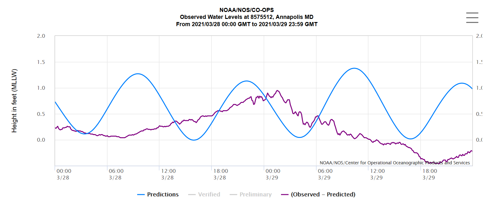
Here is an example of the predicted tidal range and the observed range over the same time period. If you peruse this site – https://tidesandcurrents.noaa.gov/waterlevels.html?id=8575512 – you can see that the predictions almost never match the observed. Keep in mind this station is at the Naval Academy basin in the Severn River, which has its own micro conditions with wind and runoff.
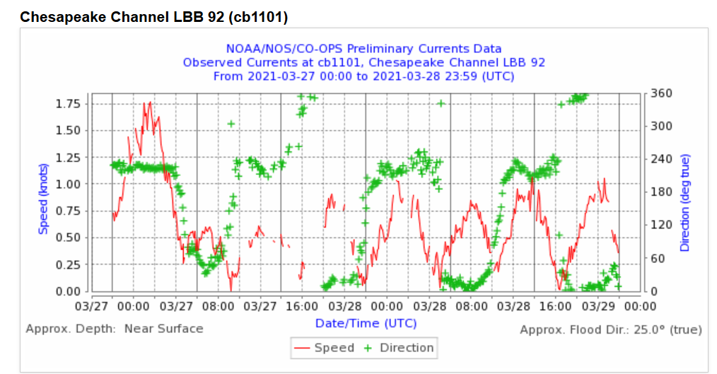
A chart of tides out in the bay near the Bay Bridge is more similar to what we might see on the course (also keep in mind this is the narrowest part of the bay in this area so will have the highest speeds):
Additionally, there are two main currents that can effect the race course: the main bay current and the Severn River current. Also as you get closer to Greenbury point, there can be an eddy that moves in the opposite direction of the bay current.
Given this variability, it is always wise to make observations on the course by watching nearby crab pot buoys, the committee boat and large ships anchored in the bay. Often if the current is strong and the wind light, these ships can be stern to the breeze. I almost never check the tide tables other than to know generally where we are in the cycle, and rely on in situ observations on the course.
Weather Resources
Fortunately we have some great local resources for observations that help us know which of the generalizations above might apply:
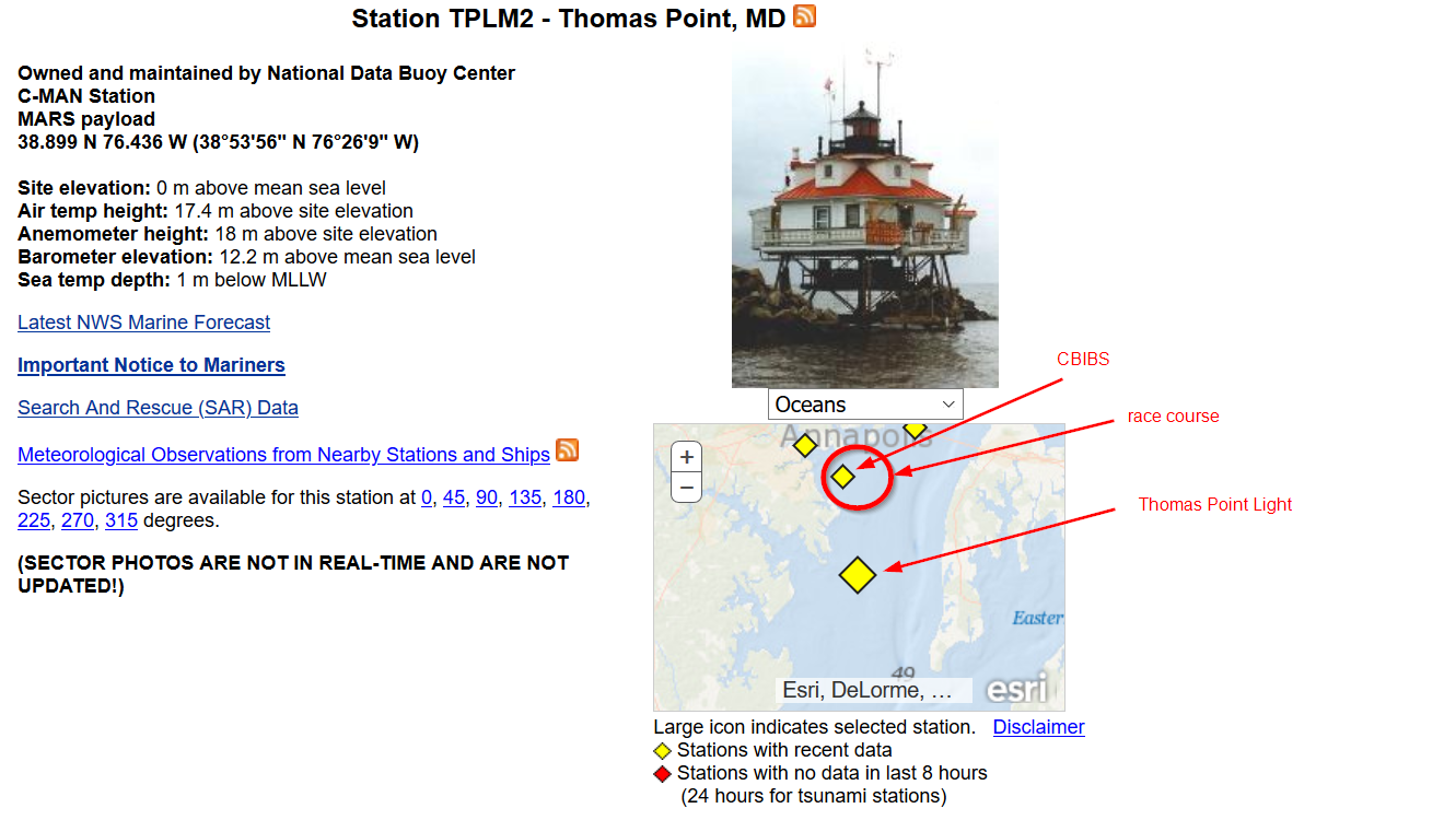
Chesapeake Bay Interpretive Buoy System/Annapolis – This buoy is essentially on the race course. You can note it by the yellow color. It has real time observations of many pieces of data and can show graphs for 1, 7, and 30 days. The wind sensors are near water level so wind strengths are what we would perceive on a Snipe.
Thomas Point Light – This station has real time and historical data and has the latest marine forecast. I like to read the forecast and interpret it based on the generalizations above. Keep in mind the sensors are about 40′ above the water so wind strength is typically higher than what we would perceive on a Snipe.
NOAA Station at USNA – Real time wind readings a the USNA boat basin. This is a good way to calibrate what you are seeing standing at SSA.
Of course Sailflow, iWindsurf and Windy are good resources, especially if you have paid versions. However, given the local variability for things like thermal effects, you have to take what the various models in these apps show with a grain of salt. I have found generally if the breeze is dominated by a well defined frontal system, the models will be accurate, but it the system is unsettled or highly driven by micro conditions, e.g. during a large high pressure sitting on us, it won’t necessarily predict the thermal effect accurately.
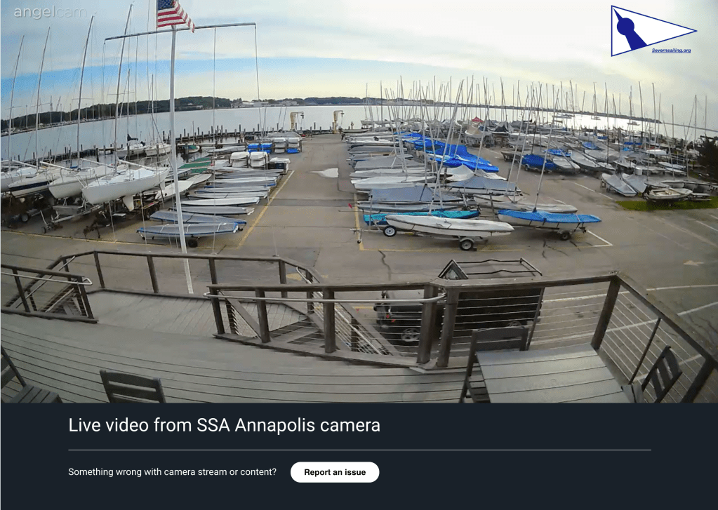
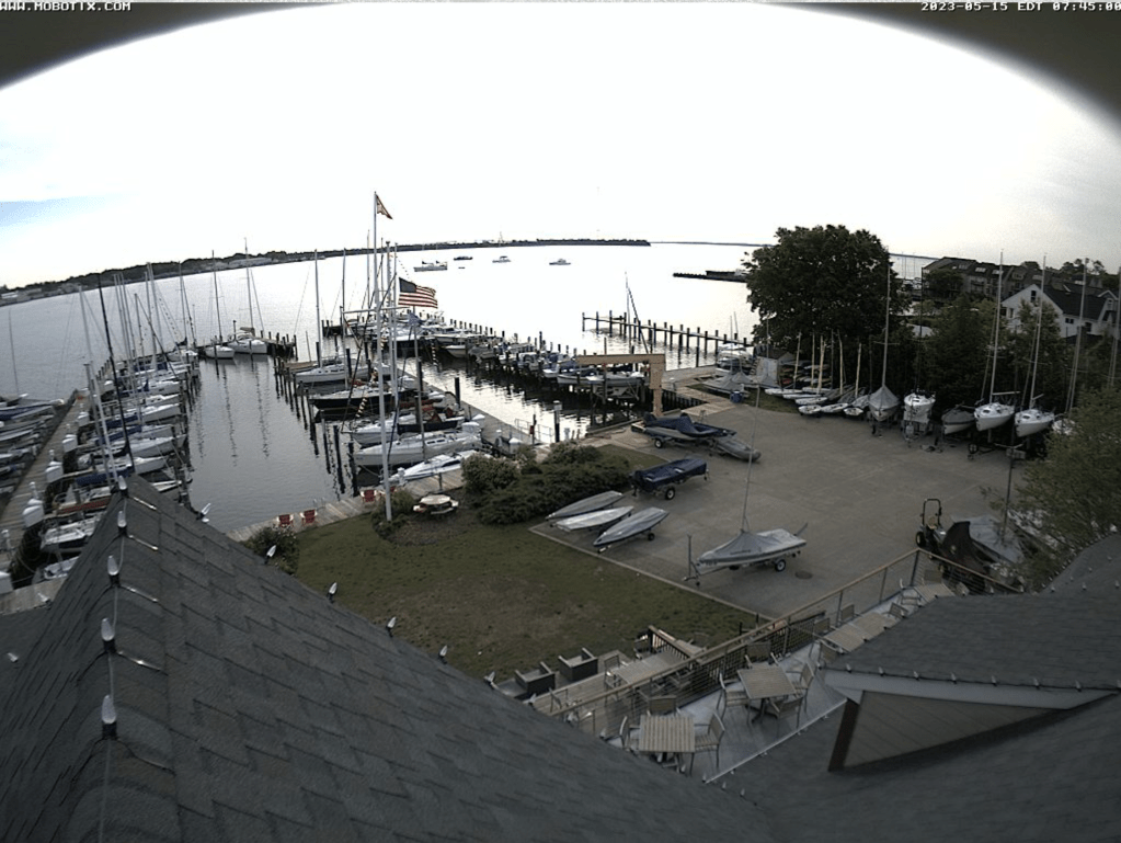
And you can always look out over the Severn River using the SSA and Eastport YC webcams (click the images or links, these are just static images):
Other SSA Venue information
Severn Sailing Association is first and foremost a one design sailing club that focuses on sailing and racing and the facilities are all related to that primary mission. While it is not a “Yacht Club” in a traditional sense, it has some great facilities. This is an outline of what to expect when you sail here.
Arriving at SSA
SSA is located in the Eastport neighborhood of Annapolis. This area is very tight with narrow streets and on Friday evenings in the summer there can be a fair amount of traffic. Often you must do what locals call the “Eastport Shuffle” by pulling over to let opposing traffic pass (or vice versa), especially if you have a trailer, but be patient and you’ll get through.
When you arrive at SSA, most likely gate to the lot will be down so you will have to get the code from the regatta organizer for a lockbox with a key fob that opens the gate. ONLY ONE VEHICLE PER GATE OPEN!! Once in the lot you have to unload your boat/trailer and remove it from the parking area and place it in the dry sail area. All of the details of where you put your boat (and trailer if you put your boat on a dolly) are unique to the particular event, so you will be instructed by the organizer at the time.
Parking during the event is always tight on the lot but is allowed for visitors on a space available basis, but visitors can also park across the street at Yacht Haven on Saturdays and Sundays. There are no restrictions on any Eastport street parking, but it’s generally not hard to find before 8am. Please listen for instructions about parking at the competitors meeting, it’s very important.
The pedestrian gate is unlocked during day as is the restrooms at the club.
Club House and Snack Bar
The clubhouse has Men’s andWomen’s bathrooms/changing room/showers and a water bottle filler on the first floor. The main area on the second floor, the “Great Room” is typically open during regattas and is air conditioned so is nice if it’s hot. There are couches and chairs to relax as well as WiFi. See the regatta organizer for the password.
Private alcohol is not allowed at SSA. However we do have a relatively full service Snack Bar. All ordering is done via a terminal under the deck, Andrea behind the window only serves the drinks and food and does not handle any transactions. It is open in the afternoon/evening but not for any breakfast. There is a variety of beer, wine and mixed drinks and several food options. See the Sycamore Point Cafe page on the SSA website for more.
Launching and Sailing to the Course
SSA has three protected “basins” for launching with bulkheads to tie to while rigging. There are three hoists, a large crane (used primarily by keelboats) in the basin nearest to the the clubhouse, and two smaller hoists in the outermost basin. The two smaller hoists are size appropriate for Snipes and are the most popular. The middle basin has a floating tock that can be used to launch form a dolly “Laser style”. This is a popular option for people who are used to doing this because you can fully rig, launch and leave the dock quickly, but definitely requires 4 people to muscle a Snipe in and out. So if you use this option make sure you have a partner team to help.
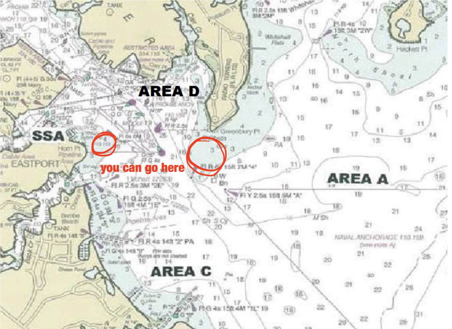
For big regattas we sail in “Area A” off Greenbury Point (the radio towers). The usual recommendation is to be in the water at least an hour before the first warning signal (that’s whey we alter the RRS for postponement ashore to be no earlier than 60 minutes from the time AP comes down. For club events and occasionally the Colonial Cup or Frigid Digit (if they are smaller attended) may be sailed off Bembe Beach (the land to the right as you exit the Severn River. Allow 30-45 minutes if the start is there.
There are no shallow water hazards that exist on the way out to either course. A Snipe can get quite close to Greenbury Point and inside the Horn Point shole pole even with the board down so you will see locals doing this, but it always is a good practice to obey the channel markers.